
Altstätten topographic map
Interactive map
Click on the map to display elevation.
About this map
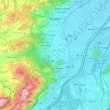
Name: Altstätten topographic map, elevation, terrain.
Location: Altstätten, Wahlkreis Rheintal, Sankt Gallen, Schweiz (47.26893 9.48395 47.40027 9.59320)
Average elevation: 679 m
Minimum elevation: 403 m
Maximum elevation: 1,785 m
An der Bürgerversammlung – die unter zweimal als Rechnungsgemeinde im April und als Budgetgemeinde im November stattfindet – wird über Voranschlag, Höhe des Gemeindesteuerfusses, Jahresrechnung, Amtsbericht und die Kredite abgestimmt.
Other topographic maps
Click on a map to view its topography, its elevation and its terrain.
Balgach
Schweiz > Sankt Gallen > Wahlkreis Rheintal
Balgach, Wahlkreis Rheintal, Sankt Gallen, 9436, Schweiz
Average elevation: 440 m
Rebstein
Schweiz > Sankt Gallen > Wahlkreis Rheintal
Rebstein, Wahlkreis Rheintal, Sankt Gallen, 9445, Schweiz
Average elevation: 462 m