
Thank you for supporting this site ❤️
Make a donation
Make a donation
Hualien County topographic map
Click on the map to display elevation.
Thank you for supporting this site ❤️
Make a donation
Make a donation
About this map
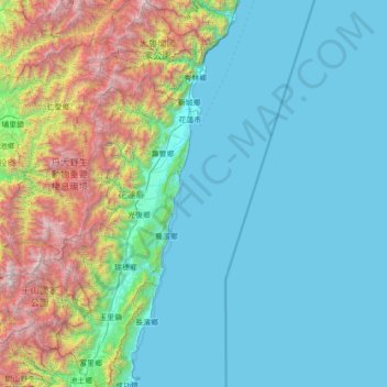
Name: Hualien County topographic map, elevation, terrain.
Location: Hualien County, Taiwan (23.09778 120.98660 24.37053 121.77382)
Average elevation: 686 m
Minimum elevation: 0 m
Maximum elevation: 3,857 m
Thank you for supporting this site ❤️
Make a donation
Make a donation
Other topographic maps
Click on a map to view its topography, its elevation and its terrain.
Thank you for supporting this site ❤️
Make a donation
Make a donation
Thank you for supporting this site ❤️
Make a donation
Make a donation
Yilan County
Yilan County is located in the northeastern Taiwan Island which covers an area of 2,143 km2. The longest distance from east to west is 63 km and from north to south is 74 km. From the mountain areas downwards, the land falls in altitude in the stages of mountains, alleys, alluvial plains, lowlands, swamps,…
Average elevation: 416 m
Thank you for supporting this site ❤️
Make a donation
Make a donation