
Eschenberg topographic map
Interactive map
Click on the map to display elevation.
About this map
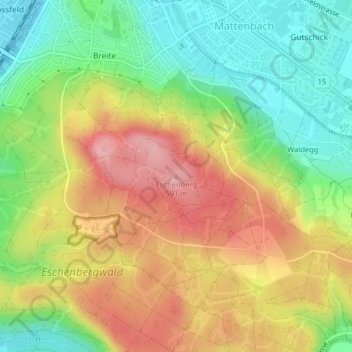
Name: Eschenberg topographic map, elevation, terrain.
Location: Eschenberg, Winterthur, Bezirk Winterthur, Zürich, 8411, Schweiz (47.48125 8.73523 47.48135 8.73533)
Average elevation: 510 m
Minimum elevation: 439 m
Maximum elevation: 589 m
Other topographic maps
Click on a map to view its topography, its elevation and its terrain.
Mörsburg
Schweiz > Zürich > Bezirk Winterthur > Winterthur > Stadel
Mörsburg, Oberwinterthur, Stadel, Winterthur, Bezirk Winterthur, Zürich, 8545, Schweiz
Average elevation: 469 m
Gotzenwil
Schweiz > Zürich > Bezirk Winterthur > Winterthur
Gotzenwil, Winterthur, Bezirk Winterthur, Zürich, 8405, Schweiz
Average elevation: 539 m