
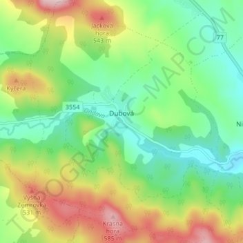
Dubová topographic map
Interactive map
Click on the map to display elevation.
About this map
Name: Dubová topographic map, elevation, terrain.
Average elevation: 395 m
Minimum elevation: 278 m
Maximum elevation: 596 m
The municipality lies at an altitude of 330 metres and covers an area of 12.546 km². It has a population of about 226 people.
Other topographic maps
Click on a map to view its topography, its elevation and its terrain.
Svidník
Slovakia > Region of Prešov > District of Svidník
Svidník, District of Svidník, Region of Prešov, Eastern Slovakia, 089 01, Slovakia
Average elevation: 311 m