
Thank you for supporting this site ❤️
Make a donation
Make a donation
Eunpyeong-gu topographic map
Click on the map to display elevation.
Thank you for supporting this site ❤️
Make a donation
Make a donation
About this map
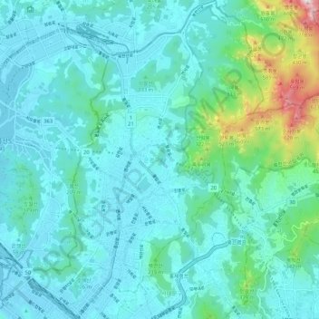
Name: Eunpyeong-gu topographic map, elevation, terrain.
Location: Eunpyeong-gu, Seoul, South Korea (37.57600 126.88206 37.65921 126.96338)
Average elevation: 125 m
Minimum elevation: 7 m
Maximum elevation: 805 m
Thank you for supporting this site ❤️
Make a donation
Make a donation
Other topographic maps
Click on a map to view its topography, its elevation and its terrain.