
Make a donation
Tetepare Island topographic map
Click on the map to display elevation.
Make a donation
About this map
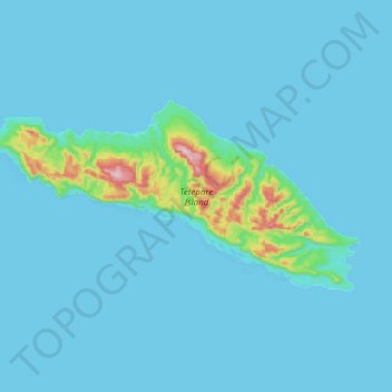
Name: Tetepare Island topographic map, elevation, terrain.
Location: Tetepare Island, Western, Solomon Islands (-8.80292 157.42911 -8.69233 157.65842)
Average elevation: 28 m
Minimum elevation: 0 m
Maximum elevation: 400 m
Make a donation
Other topographic maps
Click on a map to view its topography, its elevation and its terrain.
Vella Lavella
The island of Vella Lavella is located in the southwestern Pacific Ocean. To the north is the island of Choiseul, to the northwest is the island of Shortland, and to the southeast is the island of New Georgia. Vella Lavella is a volcanic island, surrounded in some places by a coral reef. The island contains…
Average elevation: 58 m
Kolombangara
Almost perfectly round in shape and about 30 km (19 miles) across, the island is a stratovolcano that reaches an elevation of 1,770 metres (5,807 ft) at Mount Veve. The island forms part of the southern boundary of the New Georgia Sound; to the northwest the Vella Gulf separates it from Vella Lavella and Gizo,…
Average elevation: 198 m
Make a donation