
Thank you for supporting this site ❤️
Make a donation
Make a donation
Bantargebang topographic map
Click on the map to display elevation.
Thank you for supporting this site ❤️
Make a donation
Make a donation
About this map
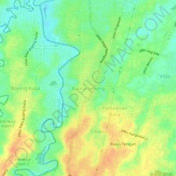
Name: Bantargebang topographic map, elevation, terrain.
Location: Bantargebang, Bekasi, West Java, Java, 17151, Indonesia (-6.34308 106.96307 -6.30308 107.00307)
Average elevation: 38 m
Minimum elevation: 20 m
Maximum elevation: 58 m
Thank you for supporting this site ❤️
Make a donation
Make a donation
Other topographic maps
Click on a map to view its topography, its elevation and its terrain.