Geolocate

Scotter CP topographic map

Interactive map

Click on the map to display elevation.

About this map

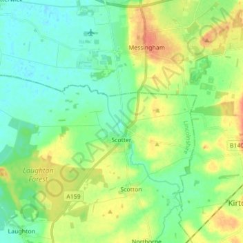
Name: Scotter CP topographic map, elevation, terrain.

Location: Scotter CP, West Lindsey, Lincolnshire, England, United Kingdom (53.48776 -0.76303 53.51991 -0.62449)

Average elevation: 15 m

Minimum elevation: -1 m

Maximum elevation: 41 m

Other topographic maps

Click on a map to view its topography, its elevation and its terrain.

Bardney CP

United Kingdom > England > Lincolnshire > West Lindsey

Bardney CP, West Lindsey, Lincolnshire, England, United Kingdom

Average elevation: 8 m

Scothern

United Kingdom > England > Lincolnshire > West Lindsey

Scothern, West Lindsey, Lincolnshire, England, LN2 2UJ, United Kingdom

Average elevation: 16 m

Sturton by Stow CP

United Kingdom > England > Lincolnshire > West Lindsey

Sturton by Stow CP, West Lindsey, Lincolnshire, England, United Kingdom

Average elevation: 13 m

Burton Waters

United Kingdom > England > Lincolnshire > West Lindsey > Burton CP

Burton Waters, Fen Farm, Burton CP, West Lindsey, Lincolnshire, England, United Kingdom

Average elevation: 6 m

Market Rasen TC

United Kingdom > England > Lincolnshire > West Lindsey

Market Rasen TC, West Lindsey, Lincolnshire, England, United Kingdom

Average elevation: 30 m

Torksey

United Kingdom > England > Lincolnshire > West Lindsey > Torksey

Torksey, West Lindsey, Lincolnshire, East Midlands, England, LN1 2EE, United Kingdom

Average elevation: 7 m