
Thank you for supporting this site ❤️
Make a donation
Make a donation
Xorazm Region topographic map
Click on the map to display elevation.
Thank you for supporting this site ❤️
Make a donation
Make a donation
About this map
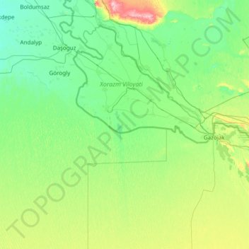
Name: Xorazm Region topographic map, elevation, terrain.
Location: Xorazm Region, Uzbekistan (40.55007 60.04651 41.99658 62.45193)
Average elevation: 116 m
Minimum elevation: 71 m
Maximum elevation: 449 m
Thank you for supporting this site ❤️
Make a donation
Make a donation
Other topographic maps
Click on a map to view its topography, its elevation and its terrain.
Thank you for supporting this site ❤️
Make a donation
Make a donation
Thank you for supporting this site ❤️
Make a donation
Make a donation
Jizzax
From the slopes of the mountains at an altitude of 1800 meters above sea level, pine forests begin. As the mountains rise, the pine forest thickens.
Average elevation: 381 m
Thank you for supporting this site ❤️
Make a donation
Make a donation