
Exbury topographic map
Interactive map
Click on the map to display elevation.
About this map
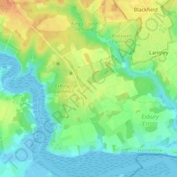
Name: Exbury topographic map, elevation, terrain.
Average elevation: 14 m
Minimum elevation: -2 m
Maximum elevation: 36 m
Other topographic maps
Click on a map to view its topography, its elevation and its terrain.
Brook
Vereinigtes Königreich > England > Hampshire > New Forest > Bramshaw
Brook, Bramshaw, New Forest, Hampshire, England, SO43 7HE, Vereinigtes Königreich
Average elevation: 65 m
Beaulieu
Vereinigtes Königreich > England > Hampshire > New Forest
Beaulieu, New Forest, Hampshire, England, Vereinigtes Königreich
Average elevation: 19 m
St Leonards
Vereinigtes Königreich > England > Hampshire > New Forest
St Leonards, Beaulieu, New Forest, Hampshire, England, SO42 7XG, Vereinigtes Königreich
Average elevation: 8 m
Brockenhurst
Vereinigtes Königreich > England > Hampshire > New Forest
Brockenhurst, New Forest, Hampshire, England, Vereinigtes Königreich
Average elevation: 39 m
East End
Vereinigtes Königreich > England > Hampshire > New Forest
East End, New Forest, Hampshire, England, SO41 5SY, Vereinigtes Königreich
Average elevation: 12 m