
Thank you for supporting this site ❤️
Make a donation
Make a donation
Fieberbrunn topographic map
Click on the map to display elevation.
Thank you for supporting this site ❤️
Make a donation
Make a donation
About this map
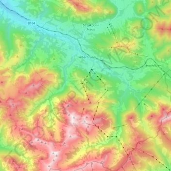
Name: Fieberbrunn topographic map, elevation, terrain.
Location: Fieberbrunn, Bezirk Kitzbühel, Tyrol, 6391, Austria (47.39233 12.48231 47.51801 12.63229)
Average elevation: 1,245 m
Minimum elevation: 672 m
Maximum elevation: 2,091 m
Thank you for supporting this site ❤️
Make a donation
Make a donation
Other topographic maps
Click on a map to view its topography, its elevation and its terrain.