
Thank you for supporting this site ❤️
Make a donation
Make a donation
Dakor topographic map
Click on the map to display elevation.
Thank you for supporting this site ❤️
Make a donation
Make a donation
About this map
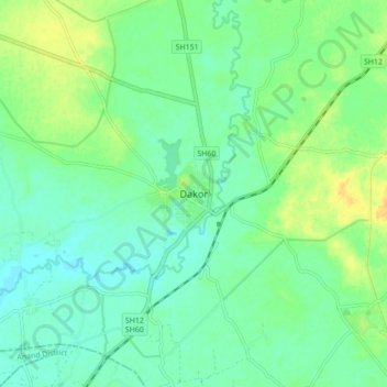
Name: Dakor topographic map, elevation, terrain.
Location: Dakor, Thasra Taluka, Kheda District, Gujarat, 388200, India (22.71284 73.11217 22.79284 73.19217)
Average elevation: 57 m
Minimum elevation: 47 m
Maximum elevation: 73 m
Thank you for supporting this site ❤️
Make a donation
Make a donation