
Jumilla topographic map
Interactive map
Click on the map to display elevation.
About this map
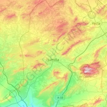
Name: Jumilla topographic map, elevation, terrain.
Location: Jumilla, Plateau, Région de Murcie, Espagne (38.28787 -1.49873 38.70400 -1.07721)
Average elevation: 618 m
Minimum elevation: 234 m
Maximum elevation: 1,338 m
Other topographic maps
Click on a map to view its topography, its elevation and its terrain.
Fuente del Pino
Espagne > Région de Murcie > Plateau > Jumilla
Fuente del Pino, Jumilla, Plateau, Région de Murcie, 30528, Espagne
Average elevation: 680 m