
Köditz topographic map
Interactive map
Click on the map to display elevation.
About this map
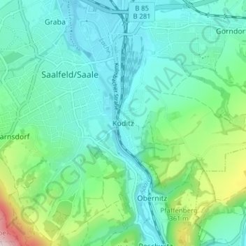
Name: Köditz topographic map, elevation, terrain.
Average elevation: 277 m
Minimum elevation: 204 m
Maximum elevation: 542 m
Other topographic maps
Click on a map to view its topography, its elevation and its terrain.
Garnsdorf
Deutschland > Thüringen > Landkreis Saalfeld-Rudolstadt > Saalfeld/Saale
Garnsdorf, Saalfeld/Saale, Probstzella, Landkreis Saalfeld-Rudolstadt, Thüringen, 07318, Deutschland
Average elevation: 333 m
Reichmannsdorf
Deutschland > Thüringen > Landkreis Saalfeld-Rudolstadt > Saalfeld/Saale
Reichmannsdorf, Saalfeld/Saale, Probstzella, Landkreis Saalfeld-Rudolstadt, Thüringen, 07318, Deutschland
Average elevation: 646 m
Gorndorf
Deutschland > Thüringen > Landkreis Saalfeld-Rudolstadt > Saalfeld/Saale > Gorndorf
Gorndorf, Saalfeld/Saale, Kamsdorf, Landkreis Saalfeld-Rudolstadt, Thüringen, Deutschland
Average elevation: 293 m
Wittgendorf
Deutschland > Thüringen > Landkreis Saalfeld-Rudolstadt > Saalfeld/Saale
Wittgendorf, Saalfeld/Saale, Landkreis Saalfeld-Rudolstadt, Thüringen, Deutschland
Average elevation: 511 m
Kleingeschwenda
Deutschland > Thüringen > Landkreis Saalfeld-Rudolstadt > Saalfeld/Saale
Kleingeschwenda, Saalfeld/Saale, Probstzella, Landkreis Saalfeld-Rudolstadt, Thüringen, 07318, Deutschland
Average elevation: 582 m
Schmiedefeld
Deutschland > Thüringen > Landkreis Saalfeld-Rudolstadt > Saalfeld/Saale
Schmiedefeld, Saalfeld/Saale, Landkreis Saalfeld-Rudolstadt, Thüringen, Deutschland
Average elevation: 678 m