
Thank you for supporting this site ❤️
Make a donation
Make a donation
Le Boulay topographic map
Click on the map to display elevation.
Thank you for supporting this site ❤️
Make a donation
Make a donation
About this map
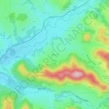
Name: Le Boulay topographic map, elevation, terrain.
Average elevation: 451 m
Minimum elevation: 377 m
Maximum elevation: 643 m
Thank you for supporting this site ❤️
Make a donation
Make a donation
Other topographic maps
Click on a map to view its topography, its elevation and its terrain.
Saint-Jean-du-Marché
France > Grand Est > Vosges > La Neuveville-devant-Lépanges
Average elevation: 504 m