
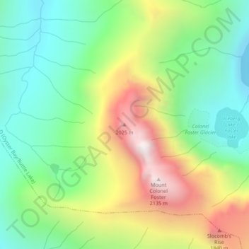
Mount Colonel Foster topographic map
Interactive map
Click on the map to display elevation.
About this map
Name: Mount Colonel Foster topographic map, elevation, terrain.
Average elevation: 1,350 m
Minimum elevation: 885 m
Maximum elevation: 2,116 m
Other topographic maps
Click on a map to view its topography, its elevation and its terrain.
Vancouver Island Ranges
Canada > British Columbia > Area D (Oyster Bay/Buttle Lake)
Vancouver Island Ranges, Area D (Oyster Bay/Buttle Lake), Strathcona Regional District, British Columbia, Canada
Average elevation: 863 m
Buttle Lake
Canada > British Columbia > Area D (Oyster Bay/Buttle Lake)
Buttle Lake, Western Mines Road, Area D (Oyster Bay/Buttle Lake), Strathcona Regional District, British Columbia, Canada
Average elevation: 1,036 m
Cream Lake
Canada > British Columbia > Area D (Oyster Bay/Buttle Lake)
Cream Lake, Flower Ridge Trail, Area D (Oyster Bay/Buttle Lake), Strathcona Regional District, British Columbia, Canada
Average elevation: 1,237 m
Landslide Lake
Canada > British Columbia > Area D (Oyster Bay/Buttle Lake)
Landslide Lake, Area D (Oyster Bay/Buttle Lake), Strathcona Regional District, British Columbia, Canada
Average elevation: 1,186 m
Volcano Lake
Canada > British Columbia > Area D (Oyster Bay/Buttle Lake)
Volcano Lake, Elk River Trail, Area D (Oyster Bay/Buttle Lake), Strathcona Regional District, British Columbia, Canada
Average elevation: 1,323 m
Mount Adrian
Canada > British Columbia > Area D (Oyster Bay/Buttle Lake)
Mount Adrian, Area D (Oyster Bay/Buttle Lake), Strathcona Regional District, British Columbia, Canada
Average elevation: 1,434 m