
Thank you for supporting this site ❤️
Make a donation
Make a donation
Richardsville topographic map
Click on the map to display elevation.
Thank you for supporting this site ❤️
Make a donation
Make a donation
About this map
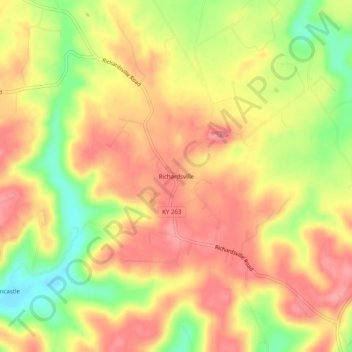
Name: Richardsville topographic map, elevation, terrain.
Location: Richardsville, Warren County, Kentucky, United States (37.08477 -86.49082 37.12477 -86.45082)
Average elevation: 182 m
Minimum elevation: 124 m
Maximum elevation: 219 m
Thank you for supporting this site ❤️
Make a donation
Make a donation
Other topographic maps
Click on a map to view its topography, its elevation and its terrain.