
Iserlohn topographic map
Interactive map
Click on the map to display elevation.
About this map
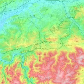
Name: Iserlohn topographic map, elevation, terrain.
Location: Iserlohn, Märkischer Kreis, Noordrijn-Westfalen, Duitsland (51.30176 7.58412 51.47365 7.74499)
Average elevation: 251 m
Minimum elevation: 103 m
Maximum elevation: 545 m
Hoewel er een aantal fietspaden door de gemeente lopen, wordt het gebruik van de fiets bemoeilijkt door de hoogteverschillen en door de omstandigheid, dat de meeste hoofdwegen door de beekdalen lopen, en fietsers deze vaak met autoverkeer moeten delen.
Other topographic maps
Click on a map to view its topography, its elevation and its terrain.
Werdohl
Duitsland > Noordrijn-Westfalen > Märkischer Kreis
Werdohl, Märkischer Kreis, Noordrijn-Westfalen, 58791, Duitsland
Average elevation: 332 m
Altena
Duitsland > Noordrijn-Westfalen > Märkischer Kreis
Altena, Märkischer Kreis, Noordrijn-Westfalen, 58762, Duitsland
Average elevation: 347 m
Neuenrade
Duitsland > Noordrijn-Westfalen > Märkischer Kreis
Neuenrade, Märkischer Kreis, Noordrijn-Westfalen, 58809, Duitsland
Average elevation: 350 m
Lüdenscheid
Duitsland > Noordrijn-Westfalen > Märkischer Kreis > Lüdenscheid
Lüdenscheid, Märkischer Kreis, Noordrijn-Westfalen, Duitsland
Average elevation: 384 m