
Cornol topographic map
Interactive map
Click on the map to display elevation.
About this map
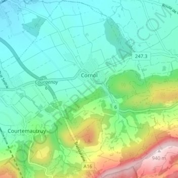
Name: Cornol topographic map, elevation, terrain.
Location: Cornol, District de Porrentruy, Jura, 2952, Suisse (47.38257 7.13574 47.42531 7.18711)
Average elevation: 579 m
Minimum elevation: 451 m
Maximum elevation: 940 m
Other topographic maps
Click on a map to view its topography, its elevation and its terrain.
Chevenez
Suisse > Jura > District de Porrentruy > Haute-Ajoie
Chevenez, Haute-Ajoie, District de Porrentruy, Jura, 2906, Suisse
Average elevation: 572 m
Damvant
Suisse > Jura > District de Porrentruy > Haute-Ajoie
Damvant, Haute-Ajoie, District de Porrentruy, Jura, 2914, Suisse
Average elevation: 624 m