
長泉町 topographic map
Interactive map
Click on the map to display elevation.
About this map
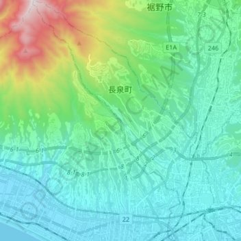
Name: 長泉町 topographic map, elevation, terrain.
Location: 長泉町, District de Suntō, Préfecture de Shizuoka, Chūbu, Japon (35.11286 138.81166 35.22121 138.91152)
Average elevation: 269 m
Minimum elevation: 0 m
Maximum elevation: 1,360 m
Other topographic maps
Click on a map to view its topography, its elevation and its terrain.
Mont Fuji
Japon > District de Suntō > Oyama
Mont Fuji, Oyama, District de Suntō, Préfecture de Shizuoka, Chūbu, Japon
Average elevation: 3,261 m