
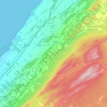
Saint-Aubert topographic map
Interactive map
Click on the map to display elevation.
About this map
Name: Saint-Aubert topographic map, elevation, terrain.
Average elevation: 210 m
Minimum elevation: 0 m
Maximum elevation: 642 m
Other topographic maps
Click on a map to view its topography, its elevation and its terrain.
Lalement
Canada > Quebec > L'Islet (MRC) > Sainte-Félicité
Lalement, Sainte-Félicité, L'Islet (MRC), Chaudière-Appalaches, Quebec, Canada
Average elevation: 373 m
Saint-Pamphile
Canada > Quebec > L'Islet (MRC)
Saint-Pamphile, L'Islet (MRC), Chaudière-Appalaches, Quebec, G0R 3X0, Canada
Average elevation: 336 m
Saint-Jean-Port-Joli
Canada > Quebec > L'Islet (MRC)
Saint-Jean-Port-Joli, L'Islet (MRC), Chaudière-Appalaches, Quebec, G0R 3G0, Canada
Average elevation: 61 m