
Make a donation
Jackson County topographic map
Click on the map to display elevation.
Make a donation
Jackson County
Most of Jackson County is a high relatively broad intermontane basin known as North Park, which covers 1,613 square miles (4,180 km2). This basin opens north into Wyoming and is rimmed on the west by the Park Range and Sierra Madre Range, on the south by the Rabbit Ears Range and the Never Summer Mountains, and on the east by the Medicine Bow Mountains. Elevations range from 7,800 to 12,953 feet (3,948 m) above sea level and is home to the head waters of the North Platte River. The term park is derived from parc, the French word for game preserve. At one time North Park was filled with herds of deer, antelope and buffalo. There were so many buffalo in the area the Ute Tribe gave North Park the name "Bull Pen." Now deer, elk, and cattle vie for the same area.
Make a donation
About this map
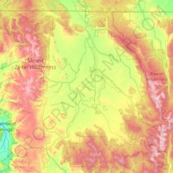
Name: Jackson County topographic map, elevation, terrain.
Location: Jackson County, Colorado, United States (40.32338 -106.87322 41.00266 -105.85176)
Average elevation: 2,751 m
Minimum elevation: 2,047 m
Maximum elevation: 3,899 m
Make a donation
Other topographic maps
Click on a map to view its topography, its elevation and its terrain.
Monument
United States > Colorado > El Paso County
Monument experiences a hemiboreal continental climate (Köppen Dfb) with warm, relatively rainy summers and cold, snowy winters. The semi-arid climate keeps the dew point very low in Monument year-round which causes the air to feel quite dry. Monument is part of the Front Range urban corridor and lies on the…
Average elevation: 2,160 m
Mountain Village
United States > Colorado > San Miguel County
Mountain Village is a home rule municipality in San Miguel County, southwestern Colorado. It is located just southwest of Telluride, Colorado in the San Juan Mountains. The elevation of the town rises above Telluride to 9,600 feet. The population was 1,264 at the 2020 census.
Average elevation: 2,917 m
Make a donation
Make a donation
Telluride
United States > Colorado > San Miguel County > Telluride
Telluride has an elevation of 8,750 feet (2,670 m) in an isolated spot in Southwest Colorado. From the west, Colorado Route 145 is the most common way into Telluride; two other passes enter the town, Imogene Pass and Black Bear Pass.
Average elevation: 3,246 m
Vail
United States > Colorado > Eagle County > Vail
Vail's average elevation is 8,150 feet (2484 m) above sea level. The town has a total area of 4.5 square miles (12 km2), with no lakes (there is, however, at least one pond). Gore Creek flows from east to west through the center of town.
Average elevation: 2,953 m
Colorado Springs
United States > Colorado > El Paso County > Colorado Springs
Snowfall is usually moderate and remains on the ground briefly because of direct sun, with the city receiving 38 inches (97 cm) per season, although the mountains to the west often receive in excess of triple that amount; March is the snowiest month in the region, both by total accumulation and number of days…
Average elevation: 2,229 m
Make a donation