
Providence County topographic map
Interactive map
Click on the map to display elevation.
About this map
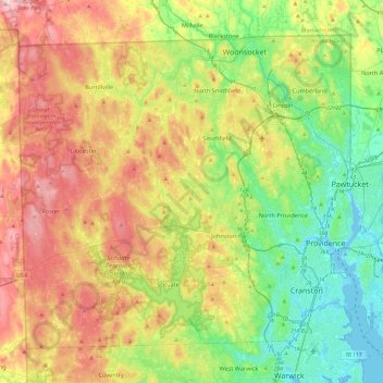
Name: Providence County topographic map, elevation, terrain.
Location: Providence County, Rhode Island, United States (41.72456 -71.79920 42.01894 -71.31774)
Average elevation: 108 m
Minimum elevation: -7 m
Maximum elevation: 272 m
Other topographic maps
Click on a map to view its topography, its elevation and its terrain.
Barrington
United States > Rhode Island > Bristol County
Barrington, Bristol County, Rhode Island, 02806, United States
Average elevation: 4 m
Burrillville
United States > Rhode Island > Providence County
Burrillville, Providence County, Rhode Island, United States
Average elevation: 155 m
Fort Wetherill
United States > Rhode Island > Newport County > Jamestown
Fort Wetherill, Highland Drive, Jamestown, Newport County, Rhode Island, 02835, United States
Average elevation: 4 m
Providence
United States > Rhode Island > Providence County
Providence, Providence County, Rhode Island, United States
Average elevation: 19 m