
Thank you for supporting this site ❤️
Make a donation
Make a donation
Dunkeswell topographic map
Click on the map to display elevation.
Thank you for supporting this site ❤️
Make a donation
Make a donation
About this map
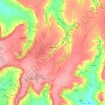
Name: Dunkeswell topographic map, elevation, terrain.
Location: Dunkeswell, East Devon, Devon, England, United Kingdom (50.82535 -3.25626 50.89504 -3.18187)
Average elevation: 218 m
Minimum elevation: 110 m
Maximum elevation: 286 m
Thank you for supporting this site ❤️
Make a donation
Make a donation
Other topographic maps
Click on a map to view its topography, its elevation and its terrain.