
Lac Renald topographic map
Interactive map
Click on the map to display elevation.
About this map
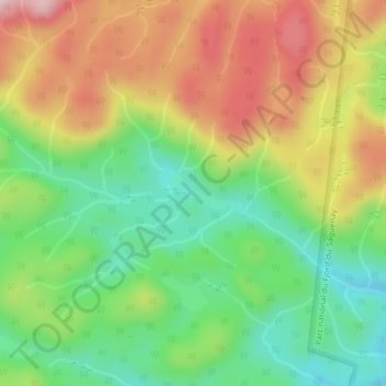
Name: Lac Renald topographic map, elevation, terrain.
Average elevation: 347 m
Minimum elevation: 220 m
Maximum elevation: 508 m
Other topographic maps
Click on a map to view its topography, its elevation and its terrain.
Lac Périgny
Canada > Québec > Rivière-Éternité
Lac Périgny, Rivière-Éternité, Le Fjord-du-Saguenay, Saguenay–Lac-Saint-Jean, Québec, Canada
Average elevation: 353 m
Rivière Éternité
Canada > Québec > Rivière-Éternité
Rivière Éternité, Rivière-Éternité, Le Fjord-du-Saguenay, Saguenay–Lac-Saint-Jean, Québec, G0V 1P0, Canada
Average elevation: 339 m
Parc national du Fjord-du-Saguenay
Canada > Québec > Rivière-Éternité
Parc national du Fjord-du-Saguenay, Sentier d'hiver, Rivière-Éternité, Le Fjord-du-Saguenay, Saguenay - Lac-Saint-Jean, Québec, Canada
Average elevation: 400 m
Lac Travers
Canada > Québec > Rivière-Éternité
Lac Travers, Sentier d'hiver, Rivière-Éternité, Le Fjord-du-Saguenay, Saguenay - Lac-Saint-Jean, Québec, Canada
Average elevation: 358 m