
Thank you for supporting this site ❤️
Make a donation
Make a donation
Papanasam topographic map
Click on the map to display elevation.
Thank you for supporting this site ❤️
Make a donation
Make a donation
Papanasam
Papanasam is located at 10°56′00″N 79°17′00″E / 10.9333°N 79.2833°E / 10.9333; 79.2833 and has an average elevation of 22 metres (72 ft). Köppen-Geiger climate classification system classifies its climate as tropical wet and dry.
Thank you for supporting this site ❤️
Make a donation
Make a donation
About this map
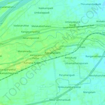
Name: Papanasam topographic map, elevation, terrain.
Location: Papanasam, Thanjavur, Tamil Nadu, 614200, India (10.88698 79.22593 10.96698 79.30593)
Average elevation: 32 m
Minimum elevation: 27 m
Maximum elevation: 40 m
Thank you for supporting this site ❤️
Make a donation
Make a donation
Other topographic maps
Click on a map to view its topography, its elevation and its terrain.
Ayyampettai
India > Tamil Nadu > Papanasam
Ayyampettai is located at 10°53′48″N 79°11′20″E / 10.896544°N 79.188978°E / 10.896544; 79.188978. It has an average elevation of 116 feet.
Average elevation: 38 m