
Wimberg topographic map
Interactive map
Click on the map to display elevation.
About this map
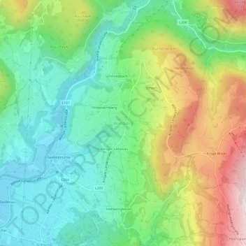
Name: Wimberg topographic map, elevation, terrain.
Location: Wimberg, Adnet, Bezirk Hallein, Salzburg, 5421, Österreich (47.69611 13.13020 47.73611 13.17020)
Average elevation: 683 m
Minimum elevation: 459 m
Maximum elevation: 1,098 m
Other topographic maps
Click on a map to view its topography, its elevation and its terrain.
Seefeldmühle
Österreich > Salzburg > Bezirk Hallein > Wimberg
Seefeldmühle, Wimberg, Adnet, Bezirk Hallein, Salzburg, 5421, Österreich
Average elevation: 598 m
Wegscheid
Österreich > Salzburg > Bezirk Hallein
Wegscheid, Abtenau, Bezirk Hallein, Salzburg, 5441, Österreich
Average elevation: 836 m
Waidach
Österreich > Salzburg > Bezirk Hallein
Waidach, Adnet, Bezirk Hallein, Salzburg, 5421, Österreich
Average elevation: 577 m
Pass Gschütt
Österreich > Salzburg > Bezirk Hallein > Rußbach am Paß Gschütt
Pass Gschütt, Rußbach am Paß Gschütt, Bezirk Hallein, Salzburg, 5442, Österreich
Average elevation: 1,041 m
Almbach
Österreich > Salzburg > Bezirk Hallein > Oberalm
Almbach, Oberalm, Bezirk Hallein, Salzburg, 5411, Österreich
Average elevation: 470 m
Gmerk
Österreich > Salzburg > Bezirk Hallein > Hallein > Bad Dürrnberg
Gmerk, Bad Dürrnberg, Hallein, Bezirk Hallein, Salzburg, 5400, Österreich
Average elevation: 771 m
Bad Vigaun
Österreich > Salzburg > Bezirk Hallein
Bad Vigaun, Bezirk Hallein, Salzburg, 5424, Österreich
Average elevation: 654 m
Wallingwinkl
Österreich > Salzburg > Bezirk Hallein
Wallingwinkl, Scheffau am Tennengebirge, Bezirk Hallein, Salzburg, 5440, Österreich
Average elevation: 785 m
Promberg
Österreich > Salzburg > Bezirk Hallein > Annaberg-Lungötz
Promberg, Annaberg-Lungötz, Bezirk Hallein, Salzburg, 5524, Österreich
Average elevation: 985 m
Fischbachreit
Österreich > Salzburg > Bezirk Hallein > Fischbach
Fischbachreit, Fischbach, Abtenau, Bezirk Hallein, Salzburg, 5441, Österreich
Average elevation: 881 m
Radochsberg
Österreich > Salzburg > Bezirk Hallein
Radochsberg, Abtenau, Bezirk Hallein, Salzburg, 5441, Österreich
Average elevation: 891 m
Steuer
Österreich > Salzburg > Bezirk Hallein > Annaberg-Lungötz > Annaberg im Lammertal
Steuer, Annaberg im Lammertal, Annaberg-Lungötz, Bezirk Hallein, Salzburg, 5524, Österreich
Average elevation: 1,011 m
Kuchl
Österreich > Salzburg > Bezirk Hallein
Kuchl, Bezirk Hallein, Salzburg, 5431, Österreich
Average elevation: 826 m
Spielbergalm
Österreich > Salzburg > Bezirk Hallein > Krispl
Spielbergalm, Krispl, Bezirk Hallein, Salzburg, 5421, Österreich
Average elevation: 1,040 m
Hallein
Österreich > Salzburg > Bezirk Hallein
Hallein, Bezirk Hallein, Salzburg, 5400, Österreich
Average elevation: 631 m
Alpendorf Dachstein West
Österreich > Salzburg > Bezirk Hallein > Annaberg-Lungötz > Annaberg im Lammertal > Alpendorf Dachstein West
Alpendorf Dachstein West, Annaberg im Lammertal, Annaberg-Lungötz, Bezirk Hallein, Salzburg, 5524, Österreich
Average elevation: 1,047 m
Voregg
Österreich > Salzburg > Bezirk Hallein > Scheffau am Tennengebirge
Voregg, Scheffau am Tennengebirge, Bezirk Hallein, Salzburg, 5440, Österreich
Average elevation: 635 m
Gseng
Österreich > Salzburg > Bezirk Hallein
Gseng, Rußbach am Paß Gschütt, Bezirk Hallein, Salzburg, 5442, Österreich
Average elevation: 1,027 m
Sankt Koloman
Österreich > Salzburg > Bezirk Hallein
Sankt Koloman, Bezirk Hallein, Salzburg, 5423, Österreich
Average elevation: 856 m
Pass Lueg
Österreich > Salzburg > Bezirk Hallein > Golling an der Salzach
Pass Lueg, Golling an der Salzach, Bezirk Hallein, Salzburg, 5440, Österreich
Average elevation: 728 m
Adnet
Österreich > Salzburg > Bezirk Hallein > Adnet > Adnet
Adnet, Bezirk Hallein, Salzburg, 5421, Österreich
Average elevation: 532 m
Schlenken
Österreich > Salzburg > Bezirk Hallein > Bad Vigaun
Schlenken, Bad Vigaun, Bezirk Hallein, Salzburg, 5424, Österreich
Average elevation: 1,207 m
Hoher Göll
Österreich > Salzburg > Bezirk Hallein > Kuchl
Hoher Göll, Kuchl, Bezirk Hallein, Salzburg, 5431, Österreich
Average elevation: 1,904 m
Abtenau
Österreich > Salzburg > Bezirk Hallein
Abtenau, Bezirk Hallein, Salzburg, 5441, Österreich
Average elevation: 1,179 m
Moos
Österreich > Salzburg > Bezirk Hallein > Jadorf > Moos
Moos, Jadorf, Kuchl, Bezirk Hallein, Salzburg, 5431, Österreich
Average elevation: 542 m
Golling an der Salzach
Österreich > Salzburg > Bezirk Hallein
Golling an der Salzach, Bezirk Hallein, Salzburg, 5440, Österreich
Average elevation: 1,234 m