
Thank you for supporting this site ❤️
Make a donation
Make a donation
Mount Orab topographic map
Click on the map to display elevation.
Thank you for supporting this site ❤️
Make a donation
Make a donation
About this map
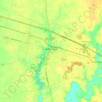
Name: Mount Orab topographic map, elevation, terrain.
Location: Mount Orab, Brown County, Ohio, 45154, United States (38.99567 -83.98408 39.05641 -83.88057)
Average elevation: 287 m
Minimum elevation: 269 m
Maximum elevation: 298 m
Thank you for supporting this site ❤️
Make a donation
Make a donation