
Greifenstein topographic map
Interactive map
Click on the map to display elevation.
About this map
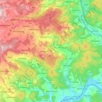
Name: Greifenstein topographic map, elevation, terrain.
Location: Greifenstein, Lahn-Dill-Kreis, Hesse, 35753, Allemagne (50.54999 8.15215 50.63358 8.36354)
Average elevation: 345 m
Minimum elevation: 133 m
Maximum elevation: 636 m
Other topographic maps
Click on a map to view its topography, its elevation and its terrain.
Dillenburg
Allemagne > Hesse > Lahn-Dill-Kreis
Dillenburg, Lahn-Dill-Kreis, Hesse, Allemagne
Average elevation: 363 m
Wetzlar
Allemagne > Hesse > Lahn-Dill-Kreis > Wetzlar
Wetzlar, Lahn-Dill-Kreis, Hesse, Allemagne
Average elevation: 232 m