
Thank you for supporting this site ❤️
Make a donation
Make a donation
Szentendre topographic map
Click on the map to display elevation.
Thank you for supporting this site ❤️
Make a donation
Make a donation
About this map
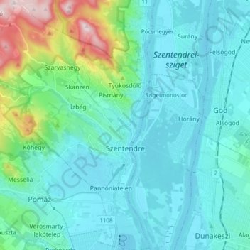
Name: Szentendre topographic map, elevation, terrain.
Location: Szentendre, Szentendrei járás, Pest, Central Hungary, Hungary (47.62573 18.97494 47.72856 19.09099)
Average elevation: 169 m
Minimum elevation: 98 m
Maximum elevation: 548 m
Thank you for supporting this site ❤️
Make a donation
Make a donation