
Irmo topographic map
Click on the map to display elevation.
About this map
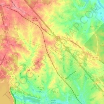
Name: Irmo topographic map, elevation, terrain.
Location: Irmo, Lexington County, South Carolina, 29212, United States (34.04721 -81.22634 34.12961 -81.15136)
Average elevation: 94 m
Minimum elevation: 44 m
Maximum elevation: 140 m
Other topographic maps
Click on a map to view its topography, its elevation and its terrain.
Batesburg
United States > South Carolina > Lexington County > Batesburg-Leesville
Average elevation: 186 m
Leesville
United States > South Carolina > Lexington County > Batesburg-Leesville
Average elevation: 190 m
Leesville
United States > South Carolina > Lexington County > Batesburg-Leesville > Leesville
Average elevation: 190 m