
Calaceite topographic map
Interactive map
Click on the map to display elevation.
About this map
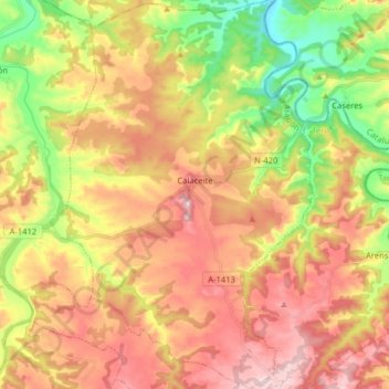
Name: Calaceite topographic map, elevation, terrain.
Location: Calaceite, Matarraña, Teruel, Aragón, 44610, España (40.95156 0.12944 41.07207 0.23772)
Average elevation: 431 m
Minimum elevation: 261 m
Maximum elevation: 589 m
El relieve del municipio es bastante irregular, con numerosos barrancos, muelas y collados. El río Algás hace de límite con la provincia de Tarragona por el noreste, concretamente, con el municipio catalán de Caseras. La altitud oscila entre los 593 m al sureste y los 270 m a orillas del río Algás. El pueblo se alza a 511 m sobre el nivel del mar, cerca del poblado ibérico de San Antonio (588 m).
Other topographic maps
Click on a map to view its topography, its elevation and its terrain.