
Hagenau topographic map
Interactive map
Click on the map to display elevation.
About this map
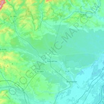
Name: Hagenau topographic map, elevation, terrain.
Average elevation: 168 m
Minimum elevation: 114 m
Maximum elevation: 518 m
Other topographic maps
Click on a map to view its topography, its elevation and its terrain.
Dimbstal
Frankreich > Grand Est > Unterelsass
Dimbstal, Zabern, Unterelsass, Grand Est, Metropolitanes Frankreich, 67440, Frankreich
Average elevation: 304 m
Westhausen
Frankreich > Grand Est > Unterelsass
Westhausen, Zabern, Unterelsass, Grand Est, Metropolitanes Frankreich, 67440, Frankreich
Average elevation: 236 m
Griesheim
Frankreich > Grand Est > Unterelsass
Griesheim, Zabern, Unterelsass, Grand Est, Metropolitanes Frankreich, 67370, Frankreich
Average elevation: 164 m
Wangen
Frankreich > Grand Est > Unterelsass
Wangen, Molsheim, Unterelsass, Grand Est, Metropolitanes Frankreich, 67520, Frankreich
Average elevation: 249 m
Butten
Frankreich > Grand Est > Unterelsass
Butten, Zabern, Unterelsass, Grand Est, Metropolitanes Frankreich, 67430, Frankreich
Average elevation: 286 m
Moorenberg
Frankreich > Grand Est > Unterelsass > Landersheim
Moorenberg, Landersheim, Zabern, Unterelsass, Grand Est, Metropolitanes Frankreich, 67700, Frankreich
Average elevation: 214 m
Hinsburg
Frankreich > Grand Est > Unterelsass
Hinsburg, Zabern, Unterelsass, Grand Est, Metropolitanes Frankreich, 67290, Frankreich
Average elevation: 319 m
Nordvogesen
Frankreich > Grand Est > Unterelsass
Nordvogesen, Unterelsass, Grand Est, Metropolitanes Frankreich, Frankreich
Average elevation: 280 m
Lembach
Frankreich > Grand Est > Unterelsass
Lembach, Hagenau-Weißenburg, Unterelsass, Grand Est, Metropolitanes Frankreich, 67510, Frankreich
Average elevation: 319 m
Blienschweiler
Frankreich > Grand Est > Unterelsass
Blienschweiler, Schlettstadt-Erstein, Unterelsass, Grand Est, Metropolitanes Frankreich, 67650, Frankreich
Average elevation: 279 m
67240
Frankreich > Grand Est > Unterelsass > Bischweiler
67240, Bischweiler, Hagenau-Weißenburg, Unterelsass, Grand Est, Metropolitanes Frankreich, Frankreich
Average elevation: 133 m
Sand
Frankreich > Grand Est > Unterelsass
Sand, Schlettstadt-Erstein, Unterelsass, Grand Est, Metropolitanes Frankreich, 67230, Frankreich
Average elevation: 157 m
Struth
Frankreich > Grand Est > Unterelsass
Struth, Zabern, Unterelsass, Grand Est, Metropolitanes Frankreich, 67290, Frankreich
Average elevation: 315 m
Forlenberg
Frankreich > Grand Est > Unterelsass > Mutzenhausen
Forlenberg, Mutzenhausen, Zabern, Unterelsass, Grand Est, Metropolitanes Frankreich, 67270, Frankreich
Average elevation: 204 m
Nieder Bruechel
Frankreich > Grand Est > Unterelsass > Bläsheim
Nieder Bruechel, Bläsheim, Straßburg, Unterelsass, Grand Est, Metropolitanes Frankreich, 67113, Frankreich
Average elevation: 155 m
Mutzig
Frankreich > Grand Est > Unterelsass
Mutzig, Molsheim, Unterelsass, Grand Est, Metropolitanes Frankreich, 67190, Frankreich
Average elevation: 257 m
Leiber
Frankreich > Grand Est > Unterelsass > Dorlisheim
Leiber, Dorlisheim, Molsheim, Unterelsass, Grand Est, Metropolitanes Frankreich, 67120, Frankreich
Average elevation: 244 m
Auenheim
Frankreich > Grand Est > Unterelsass > Rountzenheim-Auenheim
Auenheim, Rountzenheim-Auenheim, Hagenau-Weißenburg, Unterelsass, Grand Est, Metropolitanes Frankreich, 67480, Frankreich
Average elevation: 119 m
Ergersheim
Frankreich > Grand Est > Unterelsass
Ergersheim, Molsheim, Unterelsass, Grand Est, Metropolitanes Frankreich, 67120, Frankreich
Average elevation: 186 m
Pfaffenwinkel
Frankreich > Grand Est > Unterelsass > Sermersheim
Pfaffenwinkel, Sermersheim, Schlettstadt-Erstein, Unterelsass, Grand Est, Metropolitanes Frankreich, 67230, Frankreich
Average elevation: 161 m
Straßburg
Frankreich > Grand Est > Unterelsass
Straßburg, Unterelsass, Grand Est, Metropolitanes Frankreich, Frankreich
Average elevation: 144 m
Huttendorf
Frankreich > Grand Est > Unterelsass
Huttendorf, Hagenau-Weißenburg, Unterelsass, Grand Est, Metropolitanes Frankreich, 67270, Frankreich
Average elevation: 221 m
Strählen (1er Zug)
Frankreich > Grand Est > Unterelsass > Pfulgriesheim
Strählen (1er Zug), Pfulgriesheim, Zabern, Unterelsass, Grand Est, Metropolitanes Frankreich, 67370, Frankreich
Average elevation: 166 m
Taubensee
Frankreich > Grand Est > Unterelsass > Bad Niederbronn
Taubensee, Bad Niederbronn, Hagenau-Weißenburg, Unterelsass, Grand Est, Metropolitanes Frankreich, 67110, Frankreich
Average elevation: 396 m
Muckenbach
Frankreich > Grand Est > Unterelsass > Grendelbruch
Muckenbach, Grendelbruch, Molsheim, Unterelsass, Grand Est, Metropolitanes Frankreich, 67190, Frankreich
Average elevation: 564 m
Bischheim
Frankreich > Grand Est > Unterelsass
Bischheim, Straßburg, Unterelsass, Grand Est, Metropolitanes Frankreich, 67800, Frankreich
Average elevation: 142 m
Ingenheim
Frankreich > Grand Est > Unterelsass
Ingenheim, Zabern, Unterelsass, Grand Est, Metropolitanes Frankreich, 67270, Frankreich
Average elevation: 182 m
Schampenau
Frankreich > Grand Est > Unterelsass > Blen
Schampenau, Blen, Molsheim, Unterelsass, Grand Est, Metropolitanes Frankreich, 67420, Frankreich
Average elevation: 592 m
Eschweiler
Frankreich > Grand Est > Unterelsass
Eschweiler, Zabern, Unterelsass, Grand Est, Metropolitanes Frankreich, 67320, Frankreich
Average elevation: 301 m
Lingolsheim
Frankreich > Grand Est > Unterelsass
Lingolsheim, Straßburg, Unterelsass, Grand Est, Metropolitanes Frankreich, 67380, Frankreich
Average elevation: 144 m
Schaffhausen
Frankreich > Grand Est > Unterelsass
Schaffhausen, Hagenau-Weißenburg, Unterelsass, Grand Est, Metropolitanes Frankreich, 67470, Frankreich
Average elevation: 134 m
Gries
Frankreich > Grand Est > Unterelsass
Gries, Hagenau-Weißenburg, Unterelsass, Grand Est, Metropolitanes Frankreich, 67240, Frankreich
Average elevation: 145 m
Burbach
Frankreich > Grand Est > Unterelsass
Burbach, Zabern, Unterelsass, Grand Est, Metropolitanes Frankreich, 67260, Frankreich
Average elevation: 315 m
Zabern
Frankreich > Grand Est > Unterelsass
Zabern, Unterelsass, Grand Est, Metropolitanes Frankreich, 67700, Frankreich
Average elevation: 265 m
Breitenbach
Frankreich > Grand Est > Unterelsass
Breitenbach, Schlettstadt-Erstein, Unterelsass, Grand Est, Metropolitanes Frankreich, 67220, Frankreich
Average elevation: 608 m
Kaltenhausen
Frankreich > Grand Est > Unterelsass
Kaltenhausen, Hagenau-Weißenburg, Unterelsass, Grand Est, Metropolitanes Frankreich, 67240, Frankreich
Average elevation: 142 m
Bielfeld
Frankreich > Grand Est > Unterelsass > Schopperten
Bielfeld, Schopperten, Zabern, Unterelsass, Grand Est, Metropolitanes Frankreich, 67260, Frankreich
Average elevation: 234 m
Schirmeck
Frankreich > Grand Est > Unterelsass
Schirmeck, Molsheim, Unterelsass, Grand Est, Metropolitanes Frankreich, 67130, Frankreich
Average elevation: 486 m
Weißenburg
Frankreich > Grand Est > Unterelsass
Weißenburg, Hagenau-Weißenburg, Unterelsass, Grand Est, Metropolitanes Frankreich, 67160, Frankreich
Average elevation: 223 m
Lichtenberg
Frankreich > Grand Est > Unterelsass
Lichtenberg, Zabern, Unterelsass, Grand Est, Metropolitanes Frankreich, 67340, Frankreich
Average elevation: 279 m
Dossenheim
Frankreich > Grand Est > Unterelsass
Dossenheim, Zabern, Unterelsass, Grand Est, Metropolitanes Frankreich, 67330, Frankreich
Average elevation: 246 m
Sankt Peter
Frankreich > Grand Est > Unterelsass
Sankt Peter, Schlettstadt-Erstein, Unterelsass, Grand Est, Metropolitanes Frankreich, 67140, Frankreich
Average elevation: 184 m
Sankt Martin
Frankreich > Grand Est > Unterelsass
Sankt Martin, Schlettstadt-Erstein, Unterelsass, Grand Est, Metropolitanes Frankreich, 67220, Frankreich
Average elevation: 356 m
Sommerau
Frankreich > Grand Est > Unterelsass
Sommerau, Zabern, Unterelsass, Grand Est, Metropolitanes Frankreich, Frankreich
Average elevation: 316 m
Hofen
Frankreich > Grand Est > Unterelsass
Hofen, Hagenau-Weißenburg, Unterelsass, Grand Est, Metropolitanes Frankreich, 67250, Frankreich
Average elevation: 157 m
Kirchheim
Frankreich > Grand Est > Unterelsass
Kirchheim, Molsheim, Unterelsass, Grand Est, Metropolitanes Frankreich, 67520, Frankreich
Average elevation: 195 m
Selz
Frankreich > Grand Est > Unterelsass
Selz, Hagenau-Weißenburg, Unterelsass, Grand Est, Metropolitanes Frankreich, 67470, Frankreich
Average elevation: 122 m
Nordheim
Frankreich > Grand Est > Unterelsass
Nordheim, Molsheim, Unterelsass, Grand Est, Metropolitanes Frankreich, 67520, Frankreich
Average elevation: 256 m
Hördt
Frankreich > Grand Est > Unterelsass
Hördt, Hagenau-Weißenburg, Unterelsass, Grand Est, Metropolitanes Frankreich, 67720, Frankreich
Average elevation: 134 m
Rangen
Frankreich > Grand Est > Unterelsass
Rangen, Molsheim, Unterelsass, Grand Est, Metropolitanes Frankreich, 67310, Frankreich
Average elevation: 237 m