
Thank you for supporting this site ❤️
Make a donation
Make a donation
Bourne topographic map
Click on the map to display elevation.
Thank you for supporting this site ❤️
Make a donation
Make a donation
About this map
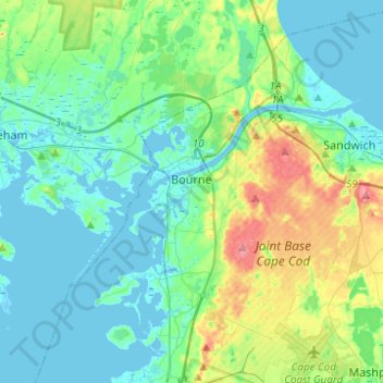
Name: Bourne topographic map, elevation, terrain.
Location: Bourne, Barnstable County, Massachusetts, United States (41.64555 -70.69096 41.82523 -70.44397)
Average elevation: 20 m
Minimum elevation: -5 m
Maximum elevation: 89 m
Thank you for supporting this site ❤️
Make a donation
Make a donation
Other topographic maps
Click on a map to view its topography, its elevation and its terrain.
Saconesset Hills
United States > Massachusetts > Barnstable County > Falmouth > Saconesset Hills
Average elevation: 10 m