
Faßmannsreuth topographic map
Interactive map
Click on the map to display elevation.
About this map
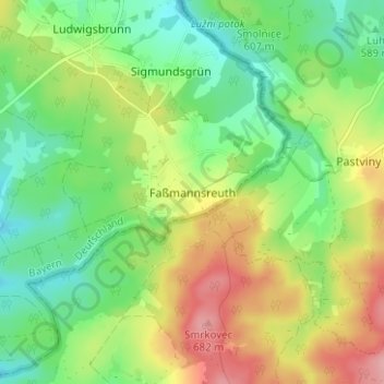
Name: Faßmannsreuth topographic map, elevation, terrain.
Location: Faßmannsreuth, Rehau, Landkreis Hof, Bayern, Deutschland (50.25177 12.10446 50.29177 12.14446)
Average elevation: 615 m
Minimum elevation: 565 m
Maximum elevation: 691 m
Other topographic maps
Click on a map to view its topography, its elevation and its terrain.
Heinersberg
Deutschland > Bayern > Landkreis Hof > Rehau
Heinersberg, Rehau, Landkreis Hof, Bayern, 95111, Deutschland
Average elevation: 567 m
Schönlind
Deutschland > Bayern > Landkreis Hof > Rehau
Schönlind, Rehau, Landkreis Hof, Bayern, 95173, Deutschland
Average elevation: 617 m