
Thank you for supporting this site ❤️
Make a donation
Make a donation
Oakland County topographic map
Click on the map to display elevation.
Thank you for supporting this site ❤️
Make a donation
Make a donation
About this map
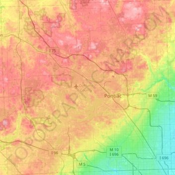
Name: Oakland County topographic map, elevation, terrain.
Location: Oakland County, Michigan, United States (42.43118 -83.68944 42.88865 -83.08339)
Average elevation: 282 m
Minimum elevation: 191 m
Maximum elevation: 382 m
Thank you for supporting this site ❤️
Make a donation
Make a donation
Other topographic maps
Click on a map to view its topography, its elevation and its terrain.
North Ottawa Dunes County Park
United States > Michigan > Ottawa County > Ferrysburg
Average elevation: 188 m
Thank you for supporting this site ❤️
Make a donation
Make a donation