
Château de Bénouville topographic map
Interactive map
Click on the map to display elevation.
About this map
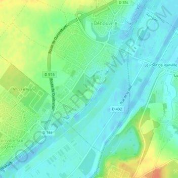
Name: Château de Bénouville topographic map, elevation, terrain.
Average elevation: 14 m
Minimum elevation: -7 m
Maximum elevation: 43 m
Other topographic maps
Click on a map to view its topography, its elevation and its terrain.
Valleuse du Curé
France > Normandie > Bénouville
Valleuse du Curé, Bénouville, Le Havre, Seine-Maritime, Normandie, France métropolitaine, 76790, France
Average elevation: 48 m