
Thank you for supporting this site ❤️
Make a donation
Make a donation
Malaybalay topographic map
Click on the map to display elevation.
Thank you for supporting this site ❤️
Make a donation
Make a donation
Malaybalay
The average elevation of the city is 622 metres (2,041 ft) above sea level. About 60% of the city's area has above 30% slope, characterized by steep hills, mountains, and cliff-like stream side. About 25% are level, gently sloping, and undulating. The rest are rolling and hilly.
Thank you for supporting this site ❤️
Make a donation
Make a donation
About this map
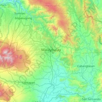
Name: Malaybalay topographic map, elevation, terrain.
Location: Malaybalay, Bukidnon, Northern Mindanao, Philippines (7.94438 124.92223 8.33614 125.41324)
Average elevation: 851 m
Minimum elevation: 286 m
Maximum elevation: 2,878 m
Thank you for supporting this site ❤️
Make a donation
Make a donation
Other topographic maps
Click on a map to view its topography, its elevation and its terrain.