
Unterrothorn topographic map
Interactive map
Click on the map to display elevation.
About this map
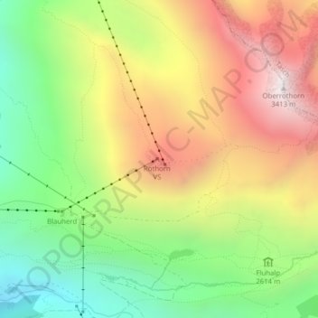
Name: Unterrothorn topographic map, elevation, terrain.
Location: Unterrothorn, Zermatt, Visp, Wallis, 3920, Schweiz (46.02143 7.79754 46.02153 7.79764)
Average elevation: 2,715 m
Minimum elevation: 2,115 m
Maximum elevation: 3,403 m
Other topographic maps
Click on a map to view its topography, its elevation and its terrain.
Schwarzsee
Schwarzsee, Hörnligrat, Chalbermatten, Zermatt, Visp, Wallis, 3920, Schweiz
Average elevation: 2,499 m
Dufourspitze (Monte Rosa)
Dufourspitze (Monte Rosa), Zermatt, Visp, Wallis, 3920, Schweiz
Average elevation: 4,033 m
Parrotspitze
Parrotspitze, Zermatt, Visp, Wallis, 3920, Schweiz
Average elevation: 3,887 m
Durandgletscher
Durandgletscher, Arbengrat, Chalbermatten, Zermatt, Visp, Wallis, 3920, Schweiz
Average elevation: 3,163 m
Liskamm westlicher Vorgipfel
Liskamm westlicher Vorgipfel, Zermatt, Visp, Wallis, 3920, Schweiz
Average elevation: 3,813 m
Zumsteinspitze
Zumsteinspitze, Zermatt, Visp, Wallis, 3920, Schweiz
Average elevation: 4,001 m