
Patancheruvu mandal topographic map
Interactive map
Click on the map to display elevation.
About this map
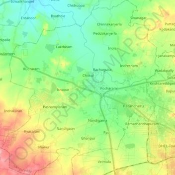
Name: Patancheruvu mandal topographic map, elevation, terrain.
Location: Patancheruvu mandal, Sangareddy, Telangana, India (17.46349 78.13716 17.62809 78.29253)
Average elevation: 541 m
Minimum elevation: 499 m
Maximum elevation: 619 m
Other topographic maps
Click on a map to view its topography, its elevation and its terrain.
Waddera Colony
India > Telangana > Patancheruvu mandal > Chitkul > Waddera Colony
Average elevation: 528 m