
Uyumbicho topographic map
Interactive map
Click on the map to display elevation.
About this map
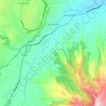
Name: Uyumbicho topographic map, elevation, terrain.
Location: Uyumbicho, Machachi, Pichincha, 171109, Ecuador (-0.46257 -78.55230 -0.36224 -78.48017)
Average elevation: 2,939 m
Minimum elevation: 2,511 m
Maximum elevation: 4,110 m
Other topographic maps
Click on a map to view its topography, its elevation and its terrain.
Santuario de Baños
Ecuador > Pichincha > Machachi > Manuel Cornejo Astorga (Tandapi)
Santuario de Baños, Manuel Cornejo Astorga (Tandapi), Machachi, Pichincha, Ecuador
Average elevation: 1,632 m
Volcán Cotopaxi
Ecuador > Pichincha > Machachi > Machachi
Volcán Cotopaxi, Machachi, Pichincha, Ecuador
Average elevation: 5,021 m