
Make a donation
Snoqualmie Pass topographic map
Click on the map to display elevation.
Make a donation
Snoqualmie Pass
Due to its elevation, Snoqualmie Pass experiences significantly lower temperatures than Seattle, and receives much more precipitation, much of it being snow. Snoqualmie Pass has a humid continental climate (Koppen: Dsb bordering Csb) with cold, very wet and snowy winters, and mild to warm, relatively dry summers.
Make a donation
About this map
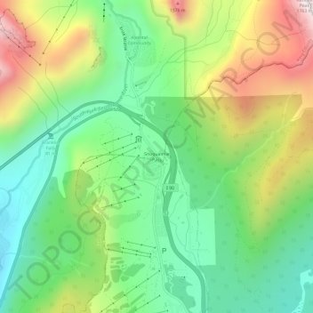
Name: Snoqualmie Pass topographic map, elevation, terrain.
Average elevation: 1,048 m
Minimum elevation: 662 m
Maximum elevation: 1,698 m
Make a donation
Other topographic maps
Click on a map to view its topography, its elevation and its terrain.
Kirkland
United States > Washington > King County
According to the United States Census Bureau, the city has a total area of 17.83 square miles (46.18 km2), of which 17.818 square miles (46.15 km2) are land and 0.012 square miles (0.03 km2) are water. The elevation varies from 14 to 500 feet (150 m) above sea level.
Average elevation: 55 m
Chester Morse Lake
United States > Washington > King County
Chester Morse Lake (originally Cedar Lake) is a lake in the upper region of the Cedar River watershed in the U.S. state of Washington. The original lake surface was 1,530 feet (466 m) above sea level, but when the river was dammed in 1900, the elevation was raised to 1,560 feet (475 m). Chester Morse Lake is…
Average elevation: 735 m
Make a donation
Snoqualmie Mill Pond
United States > Washington > King County > Snoqualmie Falls
Average elevation: 139 m
Lake City Memorial Triangle
United States > Washington > King County > Seattle
Average elevation: 61 m
Make a donation
Mercer Island
United States > Washington > King County > Mercer Island
Mercer Island City Hall is located at 47°34′39″N 122°12′43.2″W / 47.57750°N 122.212000°W / 47.57750; -122.212000 (47.5775, -122.212). The peak elevation in the city is about 338 feet (103 m), near the center of the island.
Average elevation: 39 m
Make a donation
Make a donation