
Kremsmünster topographic map
Interactive map
Click on the map to display elevation.
About this map
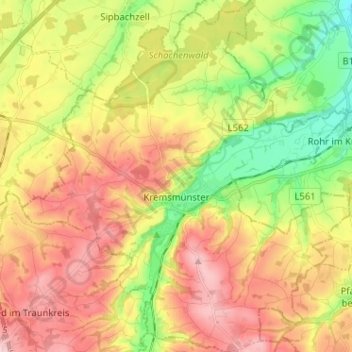
Name: Kremsmünster topographic map, elevation, terrain.
Location: Kremsmünster, Bezirk Kirchdorf, 4550, Österreich (48.01563 14.07260 48.10118 14.19180)
Average elevation: 403 m
Minimum elevation: 309 m
Maximum elevation: 494 m
Kremsmünster liegt auf 384 m Höhe im Traunviertel, an einer markanten Flussterrasse der Krems. Das Gemeindegebiet misst von Nord nach Süd 8,9 km und von West nach Ost 9,5 km. Die Gesamtfläche beträgt 42 km². 16,2 % der Fläche sind bewaldet und 71,9 % werden landwirtschaftlich genutzt.
Other topographic maps
Click on a map to view its topography, its elevation and its terrain.
Inzersdorf im Kremstal
Inzersdorf im Kremstal, Bezirk Kirchdorf, 4565, Österreich
Average elevation: 570 m
Ramsau
Österreich > Bezirk Kirchdorf > Molln
Ramsau, Molln, Bezirk Kirchdorf, 4591, Österreich
Average elevation: 769 m
Steinbach an der Steyr
Steinbach an der Steyr, Bezirk Kirchdorf, 4596, Österreich
Average elevation: 543 m
Hiersdorf
Österreich > Bezirk Kirchdorf > Wartberg an der Krems
Hiersdorf, Wartberg an der Krems, Bezirk Kirchdorf, 4552, Österreich
Average elevation: 472 m
Windischgarsten
Windischgarsten, Bezirk Kirchdorf, 4580, Österreich
Average elevation: 660 m
Hinterstoder
Hinterstoder, Bezirk Kirchdorf, 4573, Österreich
Average elevation: 1,283 m