
Thank you for supporting this site ❤️
Make a donation
Make a donation
Clearwater topographic map
Click on the map to display elevation.
Thank you for supporting this site ❤️
Make a donation
Make a donation
About this map
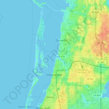
Name: Clearwater topographic map, elevation, terrain.
Location: Clearwater, Pinellas County, Florida, United States (27.93512 -82.84345 28.04996 -82.67924)
Average elevation: 8 m
Minimum elevation: -2 m
Maximum elevation: 35 m
Thank you for supporting this site ❤️
Make a donation
Make a donation
Other topographic maps
Click on a map to view its topography, its elevation and its terrain.