
Gunung Tampomas topographic map
Interactive map
Click on the map to display elevation.
About this map
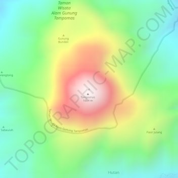
Name: Gunung Tampomas topographic map, elevation, terrain.
Location: Gunung Tampomas, Sumedang, Java occidental, Indonésie (-6.76377 107.96053 -6.76367 107.96063)
Average elevation: 1,249 m
Minimum elevation: 955 m
Maximum elevation: 1,672 m
Other topographic maps
Click on a map to view its topography, its elevation and its terrain.
Cibodas
Indonésie > Java occidental > Sumedang
Cibodas, Sumedang, Java occidental, 40395, Indonésie
Average elevation: 677 m
Sumedang
Indonésie > Java occidental > Sumedang
Sumedang, Java occidental, 45321, Indonésie
Average elevation: 681 m