
Calcena topographic map
Interactive map
Click on the map to display elevation.
About this map
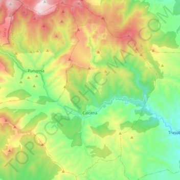
Name: Calcena topographic map, elevation, terrain.
Location: Calcena, Aranda, Saragosse, Aragon, Espagne (41.61409 -1.81311 41.72537 -1.65955)
Average elevation: 1,057 m
Minimum elevation: 647 m
Maximum elevation: 1,723 m
Other topographic maps
Click on a map to view its topography, its elevation and its terrain.
Aranda de Moncayo
Espagne > Aragon > Aranda > Aranda de Moncayo > Aranda de Moncayo
Aranda de Moncayo, Aranda, Saragosse, Aragon, Espagne
Average elevation: 885 m