
Thank you for supporting this site ❤️
Make a donation
Make a donation
Saarland topographic map
Click on the map to display elevation.
Thank you for supporting this site ❤️
Make a donation
Make a donation
About this map
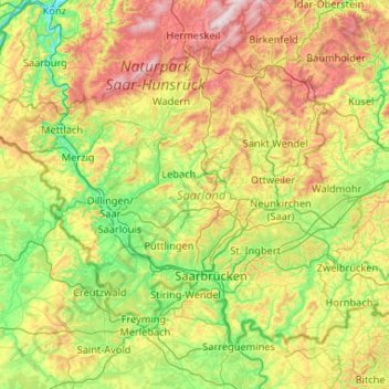
Name: Saarland topographic map, elevation, terrain.
Location: Saarland, Germany (49.11195 6.35579 49.63943 7.40483)
Average elevation: 325 m
Minimum elevation: 131 m
Maximum elevation: 761 m
Thank you for supporting this site ❤️
Make a donation
Make a donation
Other topographic maps
Click on a map to view its topography, its elevation and its terrain.
Missen - Pšyne
Germany > Brandenburg > Oberspreewald-Lausitz - Górne Błota-Łužyca > Vetschau/Spreewald
Average elevation: 72 m
Thank you for supporting this site ❤️
Make a donation
Make a donation
Wehr (Mosel)
Germany > Rhineland-Palatinate > Landkreis Trier-Saarburg > Palzem > Wehr (Mosel)
Average elevation: 201 m
Thank you for supporting this site ❤️
Make a donation
Make a donation
Leichlingen
Germany > North Rhine-Westphalia > Rheinisch-Bergischer Kreis > Leichlingen > Leichlingen
Average elevation: 95 m