
Greifswald topographic map
Interactive map
Click on the map to display elevation.
About this map
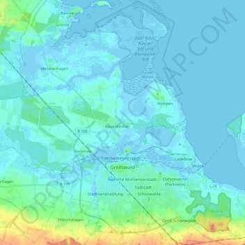
Name: Greifswald topographic map, elevation, terrain.
Average elevation: 5 m
Minimum elevation: -4 m
Maximum elevation: 36 m
Other topographic maps
Click on a map to view its topography, its elevation and its terrain.
Klein Bünzow
Allemagne > Mecklembourg-Poméranie-Occidentale > Vorpommern-Greifswald
Klein Bünzow, Züssow, Vorpommern-Greifswald, Mecklembourg-Poméranie-Occidentale, 17390, Allemagne
Average elevation: 29 m
Pudagla
Allemagne > Mecklembourg-Poméranie-Occidentale > Vorpommern-Greifswald
Pudagla, Usedom-Süd, Vorpommern-Greifswald, Mecklembourg-Poméranie-Occidentale, Allemagne
Average elevation: 4 m
Korswandt
Allemagne > Mecklembourg-Poméranie-Occidentale > Vorpommern-Greifswald
Korswandt, Usedom-Süd, Vorpommern-Greifswald, Mecklembourg-Poméranie-Occidentale, 17419, Allemagne
Average elevation: 8 m
Greifswald
Allemagne > Mecklembourg-Poméranie-Occidentale > Vorpommern-Greifswald > Greifswald > Greifswald
Greifswald, Vorpommern-Greifswald, Mecklembourg-Poméranie-Occidentale, 17489, Allemagne
Average elevation: 6 m
Pudagla
Allemagne > Mecklembourg-Poméranie-Occidentale > Vorpommern-Greifswald > Pudagla > Pudagla
Pudagla, Usedom-Süd, Vorpommern-Greifswald, Mecklembourg-Poméranie-Occidentale, 17429, Allemagne
Average elevation: 3 m
Korswandt
Allemagne > Mecklembourg-Poméranie-Occidentale > Vorpommern-Greifswald > Korswandt > Korswandt
Korswandt, Usedom-Süd, Vorpommern-Greifswald, Mecklembourg-Poméranie-Occidentale, 17419, Allemagne
Average elevation: 9 m
Faulensee
Allemagne > Mecklembourg-Poméranie-Occidentale > Vorpommern-Greifswald > Boock > Faulensee
Faulensee, Boock, Löcknitz-Penkun, Vorpommern-Greifswald, Mecklembourg-Poméranie-Occidentale, 17321, Allemagne
Average elevation: 16 m