
Varikkamukku topographic map
Interactive map
Click on the map to display elevation.
About this map
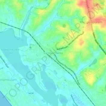
Name: Varikkamukku topographic map, elevation, terrain.
Location: Varikkamukku, Thiruvananthapuram, Kerala, 695302, India (8.59252 76.81412 8.63252 76.85412)
Average elevation: 17 m
Minimum elevation: 0 m
Maximum elevation: 61 m
Other topographic maps
Click on a map to view its topography, its elevation and its terrain.