
Thank you for supporting this site ❤️
Make a donation
Make a donation
Bontang topographic map
Click on the map to display elevation.
Thank you for supporting this site ❤️
Make a donation
Make a donation
About this map
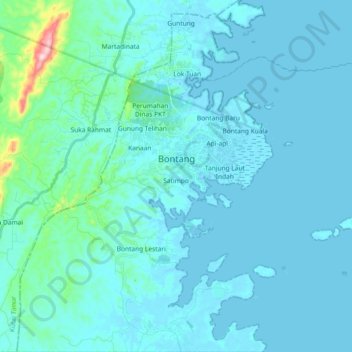
Name: Bontang topographic map, elevation, terrain.
Location: Bontang, East Kalimantan, Kalimantan, Indonesia (0.02247 117.38833 0.20608 117.56536)
Average elevation: 23 m
Minimum elevation: -2 m
Maximum elevation: 284 m
Thank you for supporting this site ❤️
Make a donation
Make a donation
Other topographic maps
Click on a map to view its topography, its elevation and its terrain.
Balikpapan
Indonesia > East Kalimantan > Balikpapan
Topography of Balikpapan is generally hilly (85%), with only small areas of flat land (15%), mostly along the coast and surrounding the hilly areas. The hills are less than 100 meters (330 feet) higher than the adjacent valleys. The altitude of Balikpapan ranges from 0 to 80 meters (260 feet) above sea level.…
Average elevation: 10 m
Thank you for supporting this site ❤️
Make a donation
Make a donation